Trails
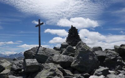
Augsbordhorn
LocationLeft bank of the Rhone, above Visp, towards Moosalp-TörbelDescriptif Superb aerial trail that runs along the easy ridges of the March Violenhorn and the Augsbordhorn for more than half of the route. Extraordinary view of the highest peaks of the Valais with...
Chinbettihöre
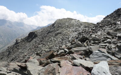
LocationLeft bank of the Rhone above Leukerbad.Descriptif T3-T4 alpine trail starting at 2315 m. Mineral scenery with remarkable geology of the formation of the Alps. You could believe you were on another Earth…Total length30 km-effortWalking time15.60 kmElevation +...
Dent de Nendaz
LocationRight bank of the Rhone above Haute-Nendaz.Descriptif T3 alpine trail for mountain lovers. Easy terrain with a ridge sometimes equipped with steps to reach the summit of the Dent. Well-marked route without orientation problems. Panorama of the Rhone plain...
Horlini
Locationright bank of the Rhone above Albinen in the Upper Valais.Descriptif easy trail without technical difficulties. Sometimes poorly marked route.Total length41 km-effortWalking time21.1 kmElevation + et -+/-1,405 mAltitude: between 1,293 and 2,455 mNational...
Klein Allalin
Locationleft bank of the Rhone, above Saas-Fee. N.B.: Departure from Saas-Almagell is also possible.Descriptif Alpine trail, in the middle of a crown of summits, each more prestigious than the last. Tough on the ankles!Total length44 km-effortWalking time21,1...
L’Aiguille
LocationLeft bank of the Rhône above St Maurice in the Bas-Valais.Descriptif A technically easy trail that allows you to quickly gain height above the plain. Pleasant and cool in summer.Total length41 km-effortWalking time19 kmElevation + et -+/-1654 mAltitude:...
L’Ardève
LocationRight bank of the Rhone above Leytron.Descriptif technically average trail with an aerial part on the summit ridge not recommended for people with a fear of heights. The summit can be avoided by going through the Mayens de Chamoson. The route is a T3 mountain...
La Croix de la Lé
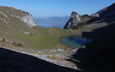
LocalisationLeft bank of the Rhône above Bouveret and St Gingolph.Descriptif A technically easy trail from the plain to the summit of the Croix de la Lé, via the mythical Cornettes de Bise and Lac de Taney. Easy orientation and well-marked paths. A magnificent route...
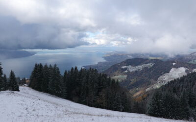
La Dent de Jaman
LocationRight bank of Lac Léman, canton Vaud, above Montreux / Glion / Caux.Descriptif Easy trail for those used to steep paths. Course in the pre-Alps, with exceptional views of Lake Geneva and its left bank, opposite the Croix de la Lé. A dream run alternating...
La Dotse
LocationLeft bank of the Rhône, in the Bas-Valais, Val Ferret, above La Fouly.Descriptif Easy mountain trail with magnificent panoramic views, bordering Italy and nearby France.Total length29 km-effortWalking time13.45 kmElevation + et -+/-1142 mAltitude: between 1639...
La Grande Garde
LocationRight bank of the Rhône, Valais-Central, in Ovronnaz above Leytron.Descriptif easy trail without any difficulties in orientation or techniques. Magnificent 180° opening onto the Rhône plain and the African tectonic plate. Enjoy the educational trail and its...
La pointe de l’Aiguille
LocationRight bank of the Rhône, in the canton of Vaud, above Villeneuve.Descriptif Medium trail for those used to steep paths or ridge paths. Starts from Villeneuve and takes just a few kilometres to reach the top of the valley. A very pretty, wild trail through a...
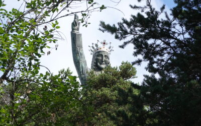
Le Christ – Roi
LocationRight bank of the Rhone above St Léonard, at the height of Lens.Descriptif Easy low altitude trail, between mountains and hills, in T2-T3 to start a season or keep fit. The trail runs along three different bisses (Clavau, Gd bisse de Lens and de Sillonin)....
Le Galihorn
LocationLeft bank of the Rhone, in the Upper Valais, on the Simplon road, above Gabi.Descriptif Medium mountain trail but requiring essential equipment such as a first aid kit, means of communication and orientation: the change of scenery is total.Total length39...
Le Grand Chavalard
LocationRight bank of the Rhone above Leytron, in Ovronnaz.Descriptif Difficult trail between forests and mountains, in T4. The route runs through the mountain pastures and touches the peaks. A great moment of happiness. Reduced equipment and possible refreshments at...
Le Mont de l’Arpille
LocationRight bank of the Rhone above Martigny in the Lower Valais.Descriptif Trail of average difficulty with steep passages equipped with chains. Route sometimes very poorly marked.Total length48 km-effortWalking time22.7 kmElevation + et -+/-1912 mAltitude: between...
Le Prabé
LocationRight bank of the Rhone above Savièse and Sion.Descriptif medium trail from the plain to the summit of Prabé, mainly in T3 but with tricky sections on the ridge overlooking the Morge de Conthey. Otherwise, paths in the vineyards and pastures, wide with very...
Le Schwarzhorn
LocationLeft bank of the Rhone above Susten-Agarn, at the height of Leuk.Descriptif difficult trail going from the plain to the summit of the Schwarzhorn, mainly in T3 and with the ascent of the summit in T4 on small sections. Wild as you want until the Ilsee: you are...
Les Ancillons
LocationRight bank of the Rhone above Ardon.Descriptif technical trail with an aerial part that allows you to reach the summit ridge, not recommended for people with a fear of heights. The route is a T3-T4 mountain path going from the plain to the summit of Ancillons...
Pointe du Six Rodze
LocationRight bank of the Rhone, Val d'Entremont after Martigny and before the Grand St Bernard pass.Descriptif Trail with exceptional views of the surrounding peaks. Pleasant climb in the forest before crossing the slopes of the coveted summit. The rocky summit...
Signalhoru
LocationLeft bank of the Rhone above Tourtemagne, Ergisch.Descriptif Alpine trail for experienced practitioners in orientation and in reading the terrain. As soon as you leave the forest, the routes are poorly marked and the crossing of scree slopes is regular....
Sparrhorn
Locationright bank of the Rhone above Blatten bei Naters in the Upper Valais.Descriptif easy trail without technical difficulties. Sometimes poorly marked route.Total length41 km-effortWalking time18.1 kmElevation + et -+/- 1,735 mAltitude: between 1,322 and 3,018...
Wyssbodehorn
Locationleft bank of the Rhone, before Simplon Dorf coming from Brig.Descriptif Wild trail, in an environment where only the scents of the alpine pastures intoxicate our nostrils.Total length28 km-effortWalking time13 kmElevation + et -+/-1132 mAltitude: between 1590...