Klettersteig Aletsch

Location
Haut-Valais, Gibidum dam reachable from Blatten bei Naters above Naters

Descriptif
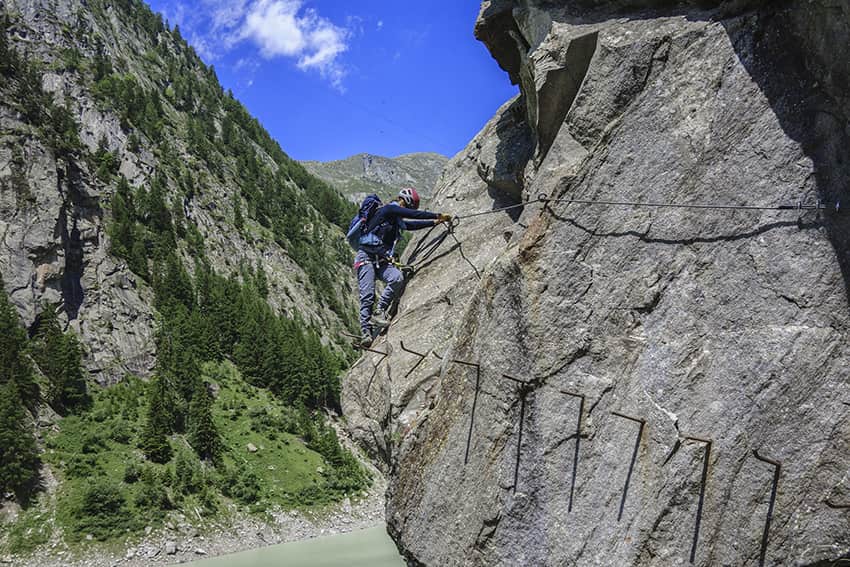
Extraordinary very difficult hike, which takes place ⅔ in a via ferrata situation and ⅓ walking around the Gibidum dam

Total length
about 3,5 km

Walking time
3 hours from the dam parking lot and 4 hours from Blatten

Elevation + et –
+/- 234 meters
Altitude: between 1435 and 1505 meters

National hiking map 1:50’000
264 Jungfrau

Best period
from June to September

Difficulty
T5
Useful information
Via ferrata equipment essential. Very good physical condition recommended and above all not being subject to vertigo. There are one or two slightly overhanging passages along the route.
If there is a problem during the first half of the route, there is a path that leaves the route at the footbridge and joins Blatten.
Itinerary
From Blatten bei Naters, follow the direction Rishinu and at the junction for Rishinu turn right into Stausee. At altitude point 1436, do not go down to the right but continue to follow the northwest foothills towards the dam wall and the (free) parking lot which is the starting point of the route, which begins at the bottom of the car park. The route goes around the Gibidum dam. It is interspersed with sections on foot and via ferrata passages that are never difficult but spectacular above the waters of the artificial lake. At the end of the right bank, the route crosses the valley via a very impressive 80 meter footbridge.
200 meters after crossing the bridge, the route joins a vertical wall which leads to a rock platform which is the ideal place for a break. From this rock platform, you must go down to the left for 20 meters towards the dam to rejoin the route.
At the end of the route, the stairs lead to the dam wall and the starting point is located 80 meters after the exit of the route.